Introduction
Unmanned Aerial Systems are used in a variety of scenarios. In this lab, we have been given five real life scenarios that unmanned aerial systems could be used in. We are to look at these scenarios and critically think how we would plan our attack by using an unmanned aerial system. Since these are vague scenarios there are some questions that arise as we are mission planning. This lab is designed to help familiarize us with one of the most up and coming job markets in technology and to gain knowledge of what kinds of unmanned aerial systems are on the market.
Types of Unmanned Aerial Systems
 Multicopters- Multicopter Unmanned Aerial Systems are perfect for tight fit areas like power lines or for a quiet approach. Multicopters can have two or more wings. Multicopters are used to fly short times from 10 to 30 minutes in length. These multicopters can be landed or can take off in a relatively small area. These are best used in tight spaces, for they can hover, go faster or slower. Here are examples of flights performed by
multicopters:
Multicopters- Multicopter Unmanned Aerial Systems are perfect for tight fit areas like power lines or for a quiet approach. Multicopters can have two or more wings. Multicopters are used to fly short times from 10 to 30 minutes in length. These multicopters can be landed or can take off in a relatively small area. These are best used in tight spaces, for they can hover, go faster or slower. Here are examples of flights performed by
multicopters:
Fixed wing- Fixed wing craft are perfect for mapping large areas. They can reach a higher altitude and stay in the air for a longer period of time compared to multicopters. This makes them perfect for terrain modelling or aerial mapping. A downside is that the do require some space for takeoff and landing, whereas multicopters do
not.
 Lighter than air- Lighter than air craft are similar to balloons and blimps. The main area is a section filled with a gas that is lighter than the surrounding air (like helium). Like multicopters, these are capable of taking off and landing vertically, making them very versatile. They are also usually cheaper than the other two. The biggest problem is the lack of control. Any wind would throw a balloon or blimp type craft off course, limiting the situations they could be used it.


Scenarios
Scenario 1
A military testing range is having problems engaging in conducting its training exercises due to the presence of desert tortoises. They currently spend millions of dollars doing ground based surveys to find their burrows. They want to know if you, as the geographer can find a better solution with UAS.
Questions before Starting:
-
How big is the survey area?
-
What time of year will the survey be done?
-
Where do desert tortoises burrow?
-
When are desert tortoises most active?
For example, desert tortoises are most active during the morning and evening hours of the spring, when the desert air is coolest (they hibernate during the winter). Locating tortoises on the military testing range would be easiest during these times, as they would be out of their burrows looking for food.
 One way of locating the creatures would be to use a gas-powered, fixed wing UAV equipped with a thermal imaging sensor and a video camera. A fixed wing craft would be able to cover more area faster than most rotary craft, and using a gas engine as opposed to an electric would enable the craft to stay in the air longer. Thermal sensors would pick up heat given off by the tortoise while it is outside of its burrow.
One problem that might arise is if the tortoise shell warms from the heat of the desert sun, therefore blending in with the surrounding rocks on a thermal imaging sensor. This is why the time of day would be very important, and the thermal camera would be supplemented with a normal video camera.
The survey area could be cut down by focusing on areas near some kind of vegetation. The animals burrows would have to be somewhat near an area where they could get food, since they do not move very quickly. Beginning the search in this area would be a good start.
 When tortoises are spotted, the technician could plot a point using a GIS program, or the UAS flight software. When the craft has finished its flight, we could send out a truck equipped with gear for collecting tortoises to those locations marked, and relocate the animals. Tortoises would not have moved far from the position they were in when the UAS spotted them.
Scenario 2
A power line company spends lots of money on a helicopter company monitoring and fixing problems on their line. One of the biggest costs is the helicopter having to fly up to these things just to see if there is a problem with the tower. Another issue is the cost of just figuring how to get to the things from the closest airport.
Questions before Starting:
-
How tall are the power lines?
-
How far is it between the towers?
-
How many miles of power line are we looking at? 2 miles or 30 miles?
-
What is the weather like?
If the weather is bad, for example if there is any wind or precipitation, the unmanned aerial system will have a harder time operating and not running into a power line.
 Since we don’t know how far we have to plan for, it would be best to imagine that we need to look at a long stretch of power line. With a long stretch of power line we will need an unmanned aerial system that can fly for a long time. Gas powered or dual battery UAS systems will be our best bet because it will allow us to view greater amounts of power line and help save the electric company money. With power lines being close together, we will need a small, versatile UAS system that has a video camera with the option to take pictures. I think being able to fly the UAS down the power line with a video/still camera would be our best option. When flying down the power line if you notice a problem you could take a still picture and see what equipment you would need to fix the problem. There are many UAS available, but the best one for this job would look like the 3DR RTF X8 with a GoPro camera attached. You can check out this UAS by clicking here and the camera here.
Here is an example of a power line tower that was surveyed by a UAS.
Scenario 3
A pineapple plantation has about 8000 acres, and they want you to give them an idea of where they have vegetation that is not healthy, as well as help them out with when might be a good time to harvest.
Since we don’t know how far we have to plan for, it would be best to imagine that we need to look at a long stretch of power line. With a long stretch of power line we will need an unmanned aerial system that can fly for a long time. Gas powered or dual battery UAS systems will be our best bet because it will allow us to view greater amounts of power line and help save the electric company money. With power lines being close together, we will need a small, versatile UAS system that has a video camera with the option to take pictures. I think being able to fly the UAS down the power line with a video/still camera would be our best option. When flying down the power line if you notice a problem you could take a still picture and see what equipment you would need to fix the problem. There are many UAS available, but the best one for this job would look like the 3DR RTF X8 with a GoPro camera attached. You can check out this UAS by clicking here and the camera here.
Here is an example of a power line tower that was surveyed by a UAS.
Scenario 3
A pineapple plantation has about 8000 acres, and they want you to give them an idea of where they have vegetation that is not healthy, as well as help them out with when might be a good time to harvest.

Pineapple plantation
Questions before Starting:
-
What time of year is it?
-
Harvest or growing season?
-
Is there a history of problems (like parasites, bacteria, fungus, etc.) on this plantation?
For a situation like this, the best thing to do would be to start with the most recent NDVI (normalized difference vegetation index) satellite data of the area. The plantation is too large to start combing the entire area with a small, unmanned craft. Using recent NDVI satellite data, we could see what areas are not as healthy. Then, once we have narrowed down our survey area, we could send out a UAS to gather data on those specific parts of the plantation. With video and infrared devices on board, we could find out why those areas are having trouble (if it is a soil issue, pest issue, etc), and plan accordingly.

Example of NDVI data
Another, cheaper option would be to use a balloon after analyzing the NDVI data. The same type of multispectral cameras could be fitted to a balloon to get images from above the plantation. The problem with this option is that you wouldn't have as much control over a balloon as you would a fixed wing or rotary device.
A gas powered fixed wing craft may be the best option, as it would be able to cover more area and remain in the air for longer periods of time, as compared to a rotary craft. After analysing the satellite images and narrowing down the area, we could send out a fixed wing craft that would circle the areas in question and gather multispectral data. Here is a company that is doing this exact thing right now.
Scenario 4
An oil pipeline running through the Niger River delta is showing some signs of leaking. This is impacting both agriculture and loss of revenue to the company.

Niger River Delta
Questions before Starting:
-
How many miles of pipeline do we have to monitor?
-
How much oil they are losing from the leaking?
There are more ways to start like remotely sensed or LIDAR images. The first, but most expensive option would be to use LIDAR data. LIDAR data are images have a closer resolution, have more depth and detail than remote sensing images from LandSat or other satellites. A good, cheap way would be to use the latest NDVI (normalized difference vegetation index) or LandSat image of the area to see where vegetation is dying or where a leak might be. If the pipeline is in two or more images you can mosaic the images together to be able to look at the full pipeline. In order to use an UAS for this situation we would have to use a very quiet and undetectable system. Niger has been through a lot of changes in the past few decades which has led to violent outbreaks. You can read about Niger and it’s history here.
Scenario 5
A mining company wants to get a better idea of the volume they remove each week. They don’t have the money for LiDAR, but want to engage in 3D analysis (Hint: look up point cloud)
Questions before Starting:
-
How large is the mine?
-
How in depth does the photo have to be?
Since they don’t have the money for LiDar they could use DroneMapper to create 3D landscape images. DroneMapper software can create 3D images from 2D aerial photos. We could send up a UAV to take still images of the mining site at the end of each week for the mining company. Those still images could then be sent in to DroneMapper for the conversion. Another way would be to have a balloon with a camera mounted on it take the pictures. An advantage of using a balloon instead of a UAV would be that it would cut down further on cost. Further information about the DroneMapper service can be found here and information about their image requirements can be found here.
How big is the survey area?
What time of year will the survey be done?
Where do desert tortoises burrow?
When are desert tortoises most active?
 One way of locating the creatures would be to use a gas-powered, fixed wing UAV equipped with a thermal imaging sensor and a video camera. A fixed wing craft would be able to cover more area faster than most rotary craft, and using a gas engine as opposed to an electric would enable the craft to stay in the air longer. Thermal sensors would pick up heat given off by the tortoise while it is outside of its burrow.
 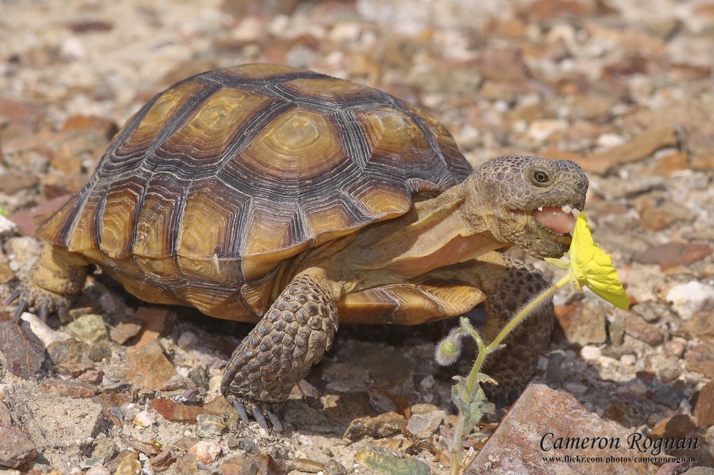 When tortoises are spotted, the technician could plot a point using a GIS program, or the UAS flight software. When the craft has finished its flight, we could send out a truck equipped with gear for collecting tortoises to those locations marked, and relocate the animals. Tortoises would not have moved far from the position they were in when the UAS spotted them.
How tall are the power lines?
How far is it between the towers?
How many miles of power line are we looking at? 2 miles or 30 miles?
What is the weather like?
 Since we don’t know how far we have to plan for, it would be best to imagine that we need to look at a long stretch of power line. With a long stretch of power line we will need an unmanned aerial system that can fly for a long time. Gas powered or dual battery UAS systems will be our best bet because it will allow us to view greater amounts of power line and help save the electric company money. With power lines being close together, we will need a small, versatile UAS system that has a video camera with the option to take pictures. I think being able to fly the UAS down the power line with a video/still camera would be our best option. When flying down the power line if you notice a problem you could take a still picture and see what equipment you would need to fix the problem. There are many UAS available, but the best one for this job would look like the 3DR RTF X8 with a GoPro camera attached. You can check out this UAS by clicking here and the camera here.
 |
| Pineapple plantation |
What time of year is it?
Harvest or growing season?
Is there a history of problems (like parasites, bacteria, fungus, etc.) on this plantation?
 |
| Example of NDVI data |
 |
| Niger River Delta |
How many miles of pipeline do we have to monitor?
How much oil they are losing from the leaking?
How large is the mine?
How in depth does the photo have to be?
No comments:
Post a Comment